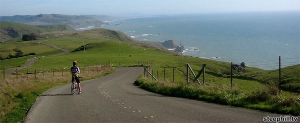
Epic and amazing might be overused adjectives, but both are applicable in describing today’s ride. While King Ridge is pretty remote, a fair number of California cyclists have made this unforgettable circuit, as it’s the meat and potatoes of the a classic fall NorCal ride – Levi Leipheimer’s Gran Fondo, perfectly slotted in first weekend of October (the 4th in 2014). If you don’t ride King Ridge, then you ride the shorter Medio or Piccolo Fondos.
There’s a plus and a minus to riding King Ridge with Levi – the plus is how well supported it is, the great food, the numerous rest stops, and the camaraderie...with 7499 other riders. I'm of the opinion that this ride is infinitely better on any other of the 364 days of the year. This way you can truly experience getting away from it all in the open spaces of rugged and rural Sonoma County without the carnival atmosphere of event participation.
We’ll begin this 50 mile, 5,000 footer from the banks of the Russian River, seven miles west of the river town of Guerneville, where the Cazadero Highway meets CA Highway 116. The most scenic route from the Bay Area is to take 116 from Highway 101 north of Petaluma; the fastest is to take River Road west, five miles north of Santa Rosa.
The Cazadero Highway is nothing more than a quiet country road, and meanders idyllically alongside beautiful Austin Creek for six and half miles until reaching Cazadero itself. Continue riding straight, creekside, onto King Road where the grade begins to gently rise until the at the 10 mile mark it begins to get interesting, progressively getting steeper as we go higher. Stunning vistas begin to open up as we get out of the tress and up on the ridge itself. We max out up here at 1600 feet and enjoy a rolling descent down to the giant oak tree at the junction with Tin Barn Rd., where King Ridge Rd. ends. A good spot to stop and fuel up for the second half of our journey, an almost mirror image of the ride profile so far.
Head south on Hauser Ridge Rd. as you roll down to the South Fork of Gualala River. The descent is fast, and be mindful of the many metal cattle crossings, particularly the one in the left hand corner just prior to the bridge - the coast is not far away and the guards can be slick in foggy weather. After the bridge comes a challenging 600 feet up to the next ridge where we the continue south on Sea View Rd. The ocean views are magnificent on clear days. At the 34 mile mark we morph into the Fort Ross Rd. for a quarter of mile before we head down to the Pacific Coast Highway via Meyers Grade Road. This is a wickedly fast, two and half mile, 1300 foot descent, made even more dicey with the distracting vistas the open rangeland affords of the Sonoma coast down to Bodega Bay. At the base turn left onto Highway 1.
At 43 miles we meet the Russian River at Jenner, where you can refresh for the easy seven miles ride back to your vehicle. Keep in mind that this ride is in very remote area, with infrequent vehicle traffic, spotty or unavailable cell phone reception, and no stores, restrooms, potable water available for 40 miles, therefore you should be not ride alone and be prepared for all eventualities - a spare tire, tools, plenty of food and an extra water bottle or hydration pack are essential.
Related Articles
